
Assessing the Correlation between Camera Angle and the Accuracy of Elevation Measurements Derived from UAV-Photogrammetry
-
DOI:
https://doi.org/10.24036/cived.v12i1.750Keywords:
Elevation, UAV-Photogrammetry, Total stationAbstract
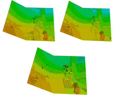
Elevation measurement is essential for various applications, including construction engineering, monitoring land subsidence, maintaining infrastructure, etc. A conventional method for elevation measurement involves terrestrial surveying using a Total Station instrument. However, this method can be time-consuming and requires a considerable number of personnel. Unmanned Aerial Vehicle (UAV) photogrammetry method offers a more efficient solution for determining elevation. This method utilizes UAVs equipped with camera sensors to capture aerial photos. In this research, aerial photos were taken using three different camera angle configurations: nadir (90°), oblique (65°), and oblique (45°). The elevation points derived from the UAV photogrammetry data were compared with the elevation measured by the Total Station. The analysis showed that the nadir (90°) camera angle configuration had the lowest Root Mean Square Error (RMSE) at 0.0471 meters, followed by the oblique (65°) configuration with RMSE of 0.0508 meters, and the obliqu (45°) configuration with RMSE of 0.1399 meters. According to the t-test, the elevations derived using the UAV photogrammetry method were not significantly different from the elevations measured with the Total Station.
Downloads
References
P. L. Raeva, S. L. Filipova, and D. G. Filipov, “Volume computation of a stockpile - A study case comparing GPS and uav measurements in an open pit quarry,” in International Archives of the Photogrammetry, Remote Sensing and Spatial Information Sciences - ISPRS Archives, International Society for Photogrammetry and Remote Sensing, 2016, pp. 999–1004. doi: 10.5194/isprsarchives-XLI-B1-999-2016.
A. A. A. Rahman, K. N. A. Maulud, F. A. Mohd, O. Jaafar, and K. N. Tahar, “Volumetric calculation using low cost unmanned aerial vehicle (UAV) approach,” IOP Conf Ser Mater Sci Eng, vol. 270, p. 012032, Dec. 2017, doi: 10.1088/1757-899X/270/1/012032.
Y. Wu, F. Meng, Y. Qin, Y. Qian, F. Xu, and L. Jia, “UAV imagery based potential safety hazard evaluation for high-speed railroad using Real-time instance segmentation,” Advanced Engineering Informatics, vol. 55, Jan. 2023, doi: 10.1016/j.aei.2022.101819.
P. Burdziakowski, “UAV in Todays Photogrammetry ? Application Areas and Challenges,” in 18th International Multidisciplinary Scientific GeoConference SGEM 2018, Jun. 2018, pp. 241–248. doi: 10.5593/sgem2018/2.3/S10.031.
P. Burdziakowski, “Towards Precise Visual Navigation and Direct Georeferencing for MAV Using ORB-SLAM2,” in 2017 Baltic Geodetic Congress (BGC Geomatics), IEEE, Jun. 2017, pp. 394–398. doi: 10.1109/BGC.Geomatics.2017.21.
M. H. Mohd Room and A. Ahmad, “Accuracy Assessment Of 3d Photogrammetric Model From Unmanned Aerial Vehicle System,” Journal of Information System and Technology Management, vol. 7, no. 25, pp. 186–194, Mar. 2022, doi: 10.35631/jistm.725015.
S. Ahmed, A. El-Shazly, F. Abed, and W. Ahmed, “The Influence of Flight Direction and Camera Orientation on the Quality Products of UAV-Based SfM-Photogrammetry,” Applied Sciences (Switzerland), vol. 12, no. 20, Oct. 2022, doi: 10.3390/app122010492.
P. Martínez-Carricondo, F. Agüera-Vega, and F. Carvajal-Ramírez, “Use of UAV-photogrammetry for Quasi-vertical wall surveying,” Remote Sens (Basel), vol. 12, no. 14, Jul. 2020, doi: 10.3390/rs12142221.
Downloads
Published
Issue
Section
License
Copyright (c) 2025 Helik Susilo, Dandung Novianto, Trias Rahardianto, Dyah Ayu Rahmawati Cupasindi, Muhamad Fajar Subkhan, Supiyono, Fuji Asema

This work is licensed under a Creative Commons Attribution 4.0 International License.


