
Land Use Changes in Batang Suliti Watershed using ArcGIS
DOI:
https://doi.org/10.24036/cived.v12i1.722Keywords:
Land Use, ArcGIS, Watershed Management, Remote SensingAbstract
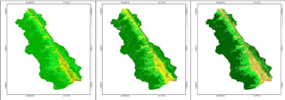
The ArcGIS application can process satellite imagery data into a land use map and calculate the area of each land use type. This study analyzes land use changes in the Batang Suliti watershed from 2013 to 2022 using ArcGIS. The study employs supervised classification and cloud masking techniques to enhance accuracy. The results indicate that forest area decreased by 4.47% with an annual change rate of 0.50%, followed by a 2.55% reduction in rice fields, while residential areas increased by 1.21%. These changes are mainly driven by population growth and agricultural expansion. The findings highlight the need for sustainable land use management policies to mitigate environmental degradation in the watershed.
Downloads
References
B. Triatmojdo, Hidrologi Terapan. Yogyakarta: Beta Offset Yogyakarta, 2009.
U. Fahad, S., Li, W., Lashari, A.H., Islam, A., Khattak, L.H., Rasool, “Evaluation of land use and land cover Spatio-temporal change during rapid Urban sprawl from Lahore, Pakistan,” Urban Clim., vol. 39, 2021, doi: https://doi.org/10.1016/j.uclim.2021.100931.
M. Gani, M.A., Sajib, A.M., Siddik, M.A., Moniruzzaman, “No Title,” Environ. Monit. Assess., vol. 195, no. 4, 2023, doi: https://doi.org/10.1007/s10661-023-10989-1.
A. I. Uddin, M.G., Nash, S., Rahman, A., Olbert, “No Title,” Water Res., 2023, doi: https://doi.org/10.1016/j.watres.119422.
A. I. Uddin, M.G., Nash, S., Rahman, A., Olbert, “No Title,” J. Clean. Prod., vol. 385, 2023, doi: https://doi.org/10.1016/j.jclepro.2022.135671.
N. A. Rif’ati, S. Nurlaela, dan C. Susetyo, “Prediksi perubahan penggunaan lahan kawasan perbatasan Kabupaten Tuban − Kabupaten Bojonegoro menggunakan GIS,” Reg. J. Pembang. Wil. dan Perenc. Partisipatif, vol. 18, no. 1, hal. 109, 2023, doi: 10.20961/region.v18i1.57383.
L. Borzì et al., “Impact of coastal land use on long-term shoreline change,” Ocean Coast. Manag., vol. 262, no. June 2024, hal. 107583, 2025, doi: 10.1016/j.ocecoaman.2025.107583.
Esri, “Band Combinations for Landsat.” Diakses: 1 Februari 2023. [Daring]. Tersedia pada: https://www.esri.com/arcgis-blog/products/product/imagery/band-combinations-for-landsat-8/
A. F. Definnas, R. F. Reyandal, E. R. Syofyan, dan W.- -, “Analisa Pengaruh Perubahan Penggunaan Lahan terhadap DAS Batang Kuranji dengan Menggunakan Model Soil and Water Assessment Tool (SWAT),” J. Ilm. Poli Rekayasa, vol. 15, no. 2, hal. 1, 2020, doi: 10.30630/jipr.15.2.161.
M. N. Qur’ani, “Analisis Perubahan Tata Guna Lahan Berbasis Geographic Information System ( Gis ),” hal. 11–54, 2023.
Y. Christian, C. Asdak, dan D. R. Kendarto, “Analisis Perubahan Penggunaan Lahan di Kabupaten Bandung Barat,” J. Teknotan, vol. 15, no. 1, hal. 15, 2021, doi: 10.24198/jt.vol15n1.3.
H. Niu, S. Chen, dan D. Xiao, “Multi-Scenario land cover changes and carbon emissions prediction for peak carbon emissions in the Yellow River Basin, China,” Ecol. Indic., vol. 168, no. October, hal. 112794, 2024, doi: 10.1016/j.ecolind.2024.112794.
Z. Jiang, Y. Li, H. Wu, A. R. Bin Mohamed Shariff, H. Zhou, dan K. Fan, “Unveiling the impacts of climate change and human activities on land-use evolution in ecologically fragile urbanizing areas: A case study of China’s Central Plains urban agglomeration,” Ecol. Indic., vol. 169, no. September, hal. 112936, 2024, doi: 10.1016/j.ecolind.2024.112936.
Y. Mathewos, B. Abate, M. Dadi, dan M. Mathewos, “The Nexus between spatiotemporal land use/land cover dynamics and ecosystem service values in the wabe river catchment, Omo Gibe River Basin, Ethiopia,” Environ. Challenges, vol. 17, no. November, hal. 101053, 2024, doi: 10.1016/j.envc.2024.101053.
P. Pemerintah, PP No. 37 tentang Pengelolaan DAS, pasal 1. 2012.
S. Baja, Perencanaan Tata Guna Lahan dalam Pengembangan Wilayah. Andi, 2012. [Daring]. Tersedia pada: http://library.itn.ac.id/digilibpusat/index.php?p=show_detail&id=6392
Kodoatie J. Robert., Rekayasa Manajemen Banjir Kota, vol. i, no. 1. 2013.
D. RRL, SK Dirjen RRL No. 041/Kpts/V/1998.
USGS, “No Title.” Diakses: 1 Februari 2023. [Daring]. Tersedia pada: https://earthexplorer.usgs.gov/
Downloads
Published
Issue
Section
License
Copyright (c) 2025 Robby Eldy Eka Putra, Junaidi, Andriani

This work is licensed under a Creative Commons Attribution 4.0 International License.


