
Lid Analysis using EPA SWMM 5.2 Application (Case Study: DPR Road Section, Padang City)
DOI:
https://doi.org/10.24036/cived.v12i1.655Keywords:
Drainage System, Rainfall, SWMM, LID, Tunggul HitamAbstract
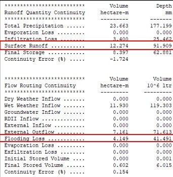
Padang City has experienced rapid development in infrastructure, but the limited green open space presents a significant challenge to the city's drainage system, resulting in frequent flooding during the rainy season which has a negative impact on the economy, health, and safety of the community. This study aims to identify the intensity of rainfall, analyze the implementation of Low-Impact Development (LID) technology and without LID implementation using EPA SWMM 5.2 software in the DPR Street area, Dadok Tunggul Hitam Village, Padang City. The practical implications of the implementation of Low Impact Development (LID) for general city management are to reduce drainage loads by managing rainfall locally, improve water quality by reducing rainfall pollution, reduce flood risks by managing rainfall effectively, improve city aesthetics by creating green and beautiful open spaces, and reduce infrastructure costs by managing rainfall locally and reducing the need for large drainage systems. The main benefits of the research results for flood management policies in Padang City are to improve the quality of life of city residents by creating a healthier and more comfortable environment, increase city resilience to climate change and natural disasters, and improve resource management efficiency by managing rainfall locally. Using 10 years of rainfall data from BMKG and primary data related to drainage channel dimensions, hydrological and hydraulic analyses and drainage system simulations were carried out. The results of the study showed that the application of LID, such as Rainfall Garden, Rainfall Barrel, Bioretention Cell, Infiltration Trench, and Permeable Pavement, application of LID an area can reduce the depth of inundation by 57,717%, the volume of runoff by 74.247%, and the peak runoff by 68,069%. The implementation of LID in an area of 73.54 Ha has proven effective in reducing the risk of flooding, strengthening drainage infrastructure, and providing sustainable solutions in dealing with urbanization in Padang City.
Downloads
References
Annisa & Deded Chandra. (2023). Kajian Perubahan Lahan Ruang Terbuka Hijau (RTH PRIVAT) Terhadap Pembangunan Komplek Palm Griya Indah II Kecamatan Lubuk Begalung Kota Padang. Jurnal Pendidikan Tambusai. Volume 7 Nomor 3. 22148-22162.
Kustyaningrum, Jagat Dhita. (2020). Perencanaan Ulang Saluran Drainase Pada Perumanhan Sutorejo, Surabaya Timur. Surabaya: Institut Teknologi Sepuluh November.
Maarifatullah, Alif. (2022). Studi Evaluasi Sistem Saluran Drainase Wilayah Ruas Jalan DPR, Kel. Dadok Tunggul Hitam, Kec. Koto Tangah, Kota Padang. Tugas Akhir. Jurusan Teknik Sipil Fakultas Teknik. Institut Teknologi Padang. Padang.
Peraturan Menteri Pekerjaan Umum Republik Indonesia Nomor 12 /Prt/M/2014 Tentang Penyelenggaraan Sistem Drainase Perkotaan.
Rossman, L.A. & Michelle A. Simon., (2022). "Storm Water Management Model User's Manual Version 5.2." U.S. Environmental Protection Agency.
Kamiana, I Made. (2011). Teknik Perhitungan Debit Rencana Bangunan Air. Yogyakarta: Graha Ilmu.
Sastra, Yola. (2023). Banjir senantiasa menjadi momok bagi masyarakat Kota Padang, Sumatera Barat. Penanganan dari hulu ke hilir mesti dilakukan. Padang.
Downloads
Published
Issue
Section
License
Copyright (c) 2025 Silta Yulan Nifen, Afdal Saputra, Angelalia Roza

This work is licensed under a Creative Commons Attribution 4.0 International License.


