Utilization of Open Polygon Method for Land Mapping in Mojoroto Kediri with Geospatial Approach
DOI:
https://doi.org/10.24036/cived.v11i3.619Keywords:
Land Mapping, LLand Area Measurements, Topographic Maps, Land Volume Analysis, Open Polygon MethodAbstract
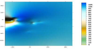
Land mapping is an important research activity to determine the location of points on the earth's surface, describing the physical condition of parts of the surface that resemble the actual condition. The objective of this process is to gain a comprehensive understanding of the land to be built and used through land area measurements, topographic maps, and land volume analysis at various altitudes. In this mapping, the open polygon method is used for calculations which are conventional methods using data point values as data centers to represent the area of influence. During this mapping, there are three main points used with the open polygon method. A total of 26 ground contours were recorded, and 4 road contours recorded. During the mapping process, corrections are required on the open polygon calculations to ensure the accuracy of the results. This correction involves adjusting the data to take into account field variability and inaccuracies of measuring instruments, so that the resulting data can be reliable for further analysis and correct decision-making. The land that has been painted can be used for various fields such as construction, and mining. Land mapping allows partial surface physical state imaging, classification of land, and can be used to plan, build, and maintain infrastructure such as highways and bridges. The result of this practice obtained data of the maximum height of 90,0945 masl and minimum 88,76 masl with the average ground height 90,05059 masl, while the average highway height is at 88,86175 masl.
Downloads
References
G. S. Airlangga, Analisis tingkat kebisingan di sekitar kawasan bandara sultan thaha jambi akibat aktivitas lalu lintas pesawat berbasis sistem informasi geografis. 2023.
M. S. Dr. Arief Darmawan, S. Hut. and S. H. Cecilinia Tika Laura, “Buku Panduan Praktikum Pemetaan Hutan dan SIG 2020,” Pandu. Prakt. Pemetaan Hutan dan SIG, vol. 11, no. 1, pp. 22–31, 2020.
Arief Rahman, Renny Puspita Sari, and ]Dian Prawira, “Sistem Informasi Geografis Pemetaan Lahan Pertanian Dan Komoditi Hasil Panen Berbasis Website,” J. Komput. dan Apl., vol. 11, no. Volume 11, No. 01 (2023), hal 83–91, pp. 83–91, 2023.
A. Basit Amir, R. Musa, and H. Ashad, “Sistem Informasi Geografis (SIG) pada Jaringan Drainase Kota Watampone,” J. Konstr., vol. 1, no. 7, pp. 40–48, 2022.
Q. R. Aliyah and B. Cahyadi, “Pemetaan Tingkat Kebisingan Pada Bengkel Pipa Dan Mess Karyawan I Dengan Metode Peta Kontur,” J. Sipil Statik, vol. 8, no. 2, pp. 249–256, 2020, [Online]. Available: https://jurnal.umj.ac.id/index.php/semnastek/article/view/14691
T. Chen, X. Zheng, R. Niu, and A. Plaza, “Open-Pit Mine Area Mapping With Gaofen-2 Satellite Images Using U-Net+,” IEEE J. Sel. Top. Appl. Earth Obs. Remote Sens., vol. 15, pp. 3589–3599, 2022, doi: 10.1109/JSTARS.2022.3171290.
F. Fahriani and Y. Apriyanti, “Pemetaan Kondisi Tanah di Pesisir Pantai Kabupaten Bangka,” J. Ilm. Rekayasa Sipil, vol. 19, no. 1, pp. 46–52, 2022, doi: 10.30630/jirs.v19i1.729.
A. Tanto, “Analisis Tumpang Tindih Penguasaan Bidang Tanah Berdasarkan Surat Pernyataan Penguasaan Fisik Bidang Tanah (SPPFBT) Dengan Sertifikat Hak Pengelolaan …,” Indones. Notary, vol. 3, 2022, [Online]. Available: https://scholarhub.ui.ac.id/notary/vol3/iss4/5/%0Ahttps://scholarhub.ui.ac.id/cgi/viewcontent.cgi?article=1139&context=notary
R. Yunita et al., “Pengukuran Perencanaan Drainase pada Pembangunan Stadion di Tanjung Haro Sikabu-Kabu,” J. Pustaka Paket Pus. Akses Kaji Pengabdi. Komput. dan Tek., vol. 2, no. 1, pp. 10–15, 2023.
H. Li, J. Q. A, and J. T. A, “Pengelolaan Air Pertanian pengurangan polusi dan peningkatan kualitas tanah di lahan pertanian miring dari Tiga,” vol. 297, no. April, 2024.
G. Yasada, “Penentuan Kontur Tanah dengan Menggunakan Teknologi Global Positioning System dan Citra Satelit Aster di Desa Manggis, Karangasem, Bali,” Matrix J. Manaj. Teknol. dan Inform., vol. 10, no. 2, pp. 58–64, 2020, doi: 10.31940/matrix.v10i2.1890.
D. Kautsar et al., “Jurnal Hukum Non Diskriminatif Dinamika Sengketa Tanah di Dago Elos Bandung Jurnal Hukum Non Diskriminatif,” vol. 2, no. 2, pp. 115–122, 2024, doi: 10.56854/jhdn.v2i2.310.
R. Kurniawan, “Aplikasi Teknologi Terkini dalam Ilmu Ukur Tanah: Pengukuran yang Akurat dan Efisien,” Ilmuteknik.Org, vol. 3, no. 3, 2024, [Online]. Available: http://ilmuteknik.org/index.php/ilmuteknik/article/view/197
S. Buana, N. Nurhakim, and R. N. Hakim, “Perhitungan Sumberdaya Batubara Menggunakan Metode Polygon Dan Metode Isoline Pada Wilayah Iup Pt Usaha Baratama Jesindo,” J. Himasapta, vol. 5, no. 1, pp. 5–8, 2020, doi: 10.20527/jhs.v5i1.2045.
I. G. K. Artika and W. Utami, “Percepatan Pembenahan Data Bidang Tanah Kluster 4 melalui Survei Data Pertanahan,” BHUMI J. Agrar. dan Pertanah., vol. 6, no. 1, pp. 66–79, 2020, doi: 10.31292/jb.v6i1.425.
A. S. Millah, Apriyani, D. Arobiah, E. S. Febriani, and E. Ramdhani, “Analisis Data dalam Penelitian Tindakan Kelas,” J. Kreat. Mhs., vol. 1, no. 2, pp. 140–153, 2023.
M. Arif, R. Hartono, and D. Arinta, “Pengembanan Laboratorium Geografi Berbasis Mobile Virtual Pada Materi Pembelajaran Praktikum Ilmu Ukur Tanah,” J. Dimens. Pendidik. dan Pembelajaran, vol. 11, no. 2, pp. 181–191, 2023, doi: 10.24269/dpp.v11i2.7006.
F. A. Eviana, “Pemetaan Kondisi Jalan Strategis Kabupaten Di Kabupaten Tulang Bawang Barat,” 2023, [Online]. Available: http://digilib.unila.ac.id/id/eprint/70851
A. Hajar, I. Nabawi, L. Kartikawati, F. R. Yudana, S. Budi, and N. Prasetiyantara, “Pengolahan Data Spasial-Geolocation Untuk Menghitung Jarak 2 Titik,” Creat. Inf. Technol. J., vol. 8, no. 1, p. 32, 2021, doi: 10.24076/citec.2021v8i1.265.
D. N. Purwati, “Pengukuran Topografi Untuk Menghitung Volume Cut and Fill Pada Perencanaan Pembangunan Perumahan Di Km. 10 Kota Balikpapan,” J. Tugas Akhir Tek. Sipil, vol. 4, no. 1, pp. 12–23, 2020.
M. R. M. Fauzan, J. Jupri, and R. Ridwana, “Pengukuran Topografi Untuk Pembangunan Penampungan Air Bersih (Studi Kasus: Daerah Rajamandala, Kabupaten Bandung Barat),” JPIG (Jurnal Pendidik. dan Ilmu Geogr., vol. 6, no. 1, pp. 35–48, 2021, doi: 10.21067/jpig.v6i1.5141.
Downloads
Published
Issue
Section
License
Copyright (c) 2024 Ricky Eka Satria Agung Permana, Imam Mustofa, Ismatul Putri Aprillinda, Zahra Purwanto, Muhammad Ali Muhdhor, Uluumul Chaq, Fadlila Ayub Ramadhani, Daniel Jalu Aufarel Wicaksono

This work is licensed under a Creative Commons Attribution 4.0 International License.


