Evaluation of the Level of Vulnerability of Flood Disaster Prone Areas in the Batang Gasan River Basin using the Weighted Product (WP) Method
DOI:
https://doi.org/10.24036/cived.v11i3.597Keywords:
Batang Gasan, River, FloodAbstract
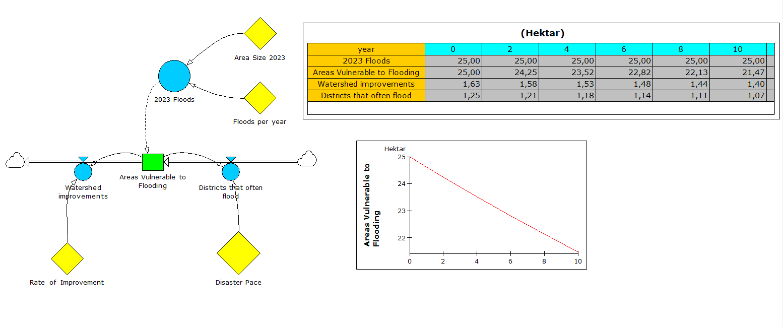
Indonesia is an area that is prone to hydro-meteorological natural disasters such as floods, landslidesand so on. In Indonesia, especially West Sumatra, the cause of flooding is dominated by high rainfall, as is the case in the Gasan Gadang watershed. In an effort to overcome problems resultingfromflooding, there are several ways, one of which is knowing the causes of flooding and the target areafor flooding, which depends on the characteristics, hydrology and physical conditions of the area. Themain objective of this study is to determine the level of vulnerability to flood disasters and tomapflood-prone areas in the Batang Gasan watershed area to obtain the level of vulnerability andverifyflood-prone areas with measurement results. This research uses several stages of analysis, namelyweighted product (WP) analysis and dynamic analysis. The research results show that areas that havea high level of flood vulnerability are IV Koto Aur Malintang sub-district and Batang Gasansub- district. The area that is vulnerable to moderate-scale flooding is Tanjung Mutiara District. Andthearea that has a low scale flood vulnerability is Sei Geringging District. For areas that are pronetohigh-scale flooding, using the Dynamic Analysis method, the area area can be reduced over the next two year period. And in the 10th (tenth) year the flood area can be reduced by 85.88%. Efforts madeto reduce the area of the flood area are by installing check dams and dredging sediment along the river for District IV Koto Aur Malintang and Batang Gasan District.
Downloads
References
Indang Dewata.Prof. 2023. Introduction eye Studying Modeling Spatial Management Environment . UNP Padang.
Aldri Frinaldi. Prof. 2024 introduction to public policy and environmental law courses. UNP Padang
Anonymous, Dep PU. 1994. Technology Control Flood in Indonesia. Directorate River, DG Irrigation
Ashdak, Chay. 2004. Hydrology And Management Area Genre River. Gadjah Mada University Press. Yogyakarta
BAKOSURTANAL, 2011, Database Prone Flood, Center Survey Source Power Natural Land, BAKOSURTANAL, Cibinong.
BNPB (National Disaster Management Agency). (2012). Disaster Data Flood Indonesia Year 1815-2013. BNPB. Jakarta (ID):
Daoed, D., Bujang, R., Bambang, I., Abdul, H. (2016) Prediction of Regional Flood Vulnerability
Department of Forestry (Dephut), Directorate of Soil Rehabilitation and Conservation. 1996. Guidelines for Identification of Watershed Characteristics. Ministry of Forestry. Jakarta.
M. Latiful Aziz, 2012. Mapping the Level of Vulnerability and Level of Flood Danger in the Central Part of the Bengawan Solo River Basin (DAS) in Bojonegoro Regency.
Suwardi. 1999. Identification and Mapping of Flood Prone Areas in Some Municipalities
Semarang Using Geographic Information Systems [thesis]. Bogor: Postgraduate Program, Bogor Agricultural Institute.

Downloads
Published
Issue
Section
License
Copyright (c) 2024 Apriwandi Arlius, Aldri Frinaldi, Rembrandt Rembrandt, Dasman Lanin, Genius Umar

This work is licensed under a Creative Commons Attribution 4.0 International License.

