
Spatial Analysis of Modeling Potential Flood Areas in Padang City using Google Earth Engine
DOI:
https://doi.org/10.24036/cived.v11i2.576Keywords:
Padang, Flooding, Google Earth Engine, Geopatial, Imagery SatelliteAbstract
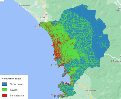
Flooding in Indonesia tends to increase from year to year, and one of the causes is high rainfall. Padang City is one of the areas that has high rainfall intensity which can trigger flooding. This research aims to present spatial information on flood-prone areas by processing data in Google Earth Engine (GEE) and determine the level of flood vulnerability in Padang City. GEE is a platform capable of processing geopatial data on a large scale using multi-temporal imagery and utilizing cloud computing technology that allows solving large problems in a short time. This research uses CHIRPS Dayli data: Climate Hazard Group Infrared Precipitation, NASA SRTM Digital Elevation 30 m, Sentinel 2-A and research administrative boundaries. This study uses rainfall, elevation, TPI, NDWI and NDVI parameters. Data analysis and processing in this study were fully carried out in GEE. The results showed that the area very prone to flooding has an area of 5569.46 ha or 8.03%. The prone area is 28064.57 ha or 40.46% and the non-prone area is 35726.20 ha or 51.51%. The results of this research are expected to help the government in flood mitigation in Padang City.
Downloads
References
M. K. O. Yuanda and A. Yulfa, “Pemetaan Tingkat Ancaman Bencana Banjir Di Kota Padang,” vol. 22, no. 1, pp. 45–50, 2022.
U. F. Arshinta and D. Ahmad, “Analisis Curah Hujan di Kota Padang dengan Menggunakan Rantai Markov,” J. Math. UNP, vol. 2, no. 4, pp. 45–50, 2019.
N. Sugandhi and H. Rakuasa, “Utilization of Geogle Earth Engine for Flood Hazard Analysis in DKI Jakarta Province,” J. Ris. Multidisiplin dan Inov. Teknol., vol. 1, no. 02, pp. 41–49, 2023, doi: 10.59653/jimat.v1i02.216.
J. Suryanto, Amprin, and Anisum, “Validasi Curah Hujan Harian Chirps Precipitation Satellite Product Di Provinsi Kalimantan Barat,” J. Ilm. Rekayasa Pertan. dan Biosist., vol. 11, no. 1, pp. 73–88, Mar. 2023, doi: 10.29303/jrpb.v11i1.442.
J. O. Olusina and C. J. Okolie, “Visualisation of Uncertainty in 30m Resolution Global Digital Elevation Models: SRTM v3.0 and ASTER v2,” Niger. J. Technol. Dev., vol. 15, no. 3, p. 77, 2018, doi: 10.4314/njtd.v15i3.2.
B. A. R. Apriyeni, N. Mubarokah, and M. Ramli, “Topographic Position Indeks Analisys untuk Interpretasi Landform Pulau Lombok Berdasarkan Digital Elevation Model (DEM),” Geodika J. Kaji. Ilmu dan Pendidik. Geogr., vol. 6, no. 2, pp. 264–273, 2022, doi: 10.29408/geodika.v6i2.7031.
M. Lestari, Mira, S. Y. J. Prasetyo, and C. Fibriani, “Analisis Daerah Rawan Banjir Pada Daerah Aliran Sungai Tuntang Menggunakan Skoring dan Inverse Distance Weighted,” Indones. J. Comput. Model., vol. 4, no. 1, pp. 1–9, 2021, doi: 10.24246/icm.v4i1.4615.
K. Dyson, A. P. Nicolau, D. Saah, and N. Clinton, Image Manipulation: Bands, Arithmetic, Thresholds, and Masks. Springer International Publishing, 2024.
A. Muin and H. Rakuasa, “Pemanfaat Geographic Artificial Intelligence (Geo-AI) Untuk Identifikasi Daerah Rawan Banjir Di Kota Ambon,” Gudang J. Multidisiplin Ilmu, vol. 1, no. 2, pp. 58–63, 2023.
H. Rakuasa, D. A. Sihasale, M. C. Mehdila, and A. P. Wlary, “Analisis Spasial Tingkat Kerawanan Banjir di Kecamatan Teluk Ambon Baguala, Kota Ambon,” vol. 3, no. 2, pp. 60–69, 2022.
E. Manakane, C. Latue, G. Somae, H. Rakuasa, S. E. Manakane, and P. C. Latue, “Flood Risk Modeling in Buru Island, Maluku Province, Indonesia using Google Earth Engine,” Mult. J. Glob. Multidiscip., vol. 1, no. 2, pp. 80–87, 2023.
H. Rakuasa and D. A. Sihasale, “Analysis of Vegetation Index in Ambon City Using Sentinel-2 Satellite Image Data with Normalized Difference Vegetation Index (NDVI) Method based on Google Earth Engine,” J. Innov. Inf. Technol. Appl., vol. 5, no. 1, pp. 74–82, 2023, doi: 10.35970/jinita.v5i1.1869.
S. Mishra, “Cloud masking over glacial snow cover using Sentinel-2 cloud products and semi-supervised image classification in the Indian Western Himalayas,” (Master’s thesis, University of Twente)., 2022.
J. A. Cardille, M. A. Crowley, D. Saah, and N. E. Clinton, Cloud-Based Remote Sensing with Google Earth Engine. 2024.
U. Gandhi, Aggregating Images for Time Series. Springer International Publishing, 2024.
Downloads
Published
Issue
Section
License
Copyright (c) 2024 Rahmi Yunika, Faisal Ashar

This work is licensed under a Creative Commons Attribution 4.0 International License.


