
Analysis Placement of Tsunami Vertical Evacuation Shelters Based on Number and Location (Case Study: Painan City)
DOI:
https://doi.org/10.24036/cived.v11i2.574Keywords:
Shelter, Tsunami, ArcGIS, Evacuation, InudationAbstract
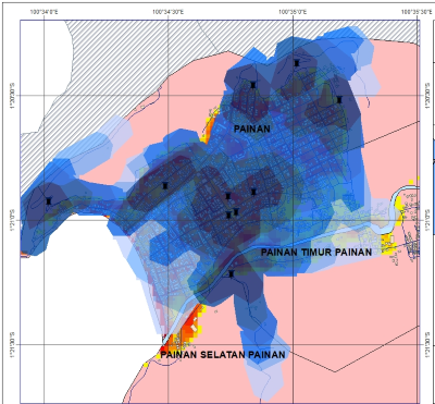
Painan City is a city whose part of the area is located on the coast, so it is prone to tsunami disasters. This disaster is unpredictable and can occur at any time. Based on interview data with BPBD South Pesisir Regency, Painan City has 10 shelters ranging from; official shelters, buildings that are multifunctional as shelters, and natural shelters. The purpose of this study is to determine the range of services of the tsunami shelter in Painan City today. The research method used is a quantitative descriptive method. In this study, what was discussed was the evaluation of the number and location of existing shelters, as well as determining the location of planned or additional tsunami shelters, as well as to determine the coverage of areas that can be served by these shelters with the help of GIS applications. Based on the results of the analysis, it was found that the entire tsunami danger zone area of Painan City could be served by existing shelters, in a span of 26 minutes with a distance of 1,171.56 meters. This means that people in the tsunami danger zone can evacuate safely before the tsunami disaster comes.
Downloads
References
BPS. (2023). What is the population of Indonesia? indonesiabaik.id. https://indonesiabaik.id/infografis/berapa-nomor-penbangun-indonesia-ya#:~:text=Based on data from the Central Statistics Agency, as many as 272%2C68 million people.
Nurrady I., T., Sutikno, S., Department of Civil Engineering, M., & Department of Civil Engineering, D. (2015). Study of Escape Building Configuration for Evacuation of the Tsunami Disaster in Banda Aceh City. Let's FTEKNIK, 2(2), 1.
Gersanandi, P. Subardjo, & A. Anugroho DS. (2013). Spatial Analysis of Tsunami Disaster Vulnerability in Coastal Regencies and Cities of West Sumatra Province. Journal of Oceanography, 2(3), 232–237.
Natawidjadja, D. H. (2007). Earthquake and Tsunami in Sumatra and Efforts to Develop a Living Environment that is Safe from Natural Disasters. Earthquake, 1–3(December), 66.
Imani, R., Boy, W., Dewi, U., Sari, A., Purba, W., Chairi, M., & Melasari, J. (2019). Assessment for Seismic Activities in Pesisir Selatan West Sumatra in 2018. Journal of Physics: Conference Series, 1339(1). https://doi.org/10.1088/1742-6596/1339/1/012003
South Pesisir Regency Central Statistics Agency. (2024). Population Number Based on Administrative Records According to Gender and Nagari in District IV Jurai (Jiwa), 2022. pesselkab.bps.go.id. https://pesselkab.bps.go.id/indicator/12/245/1/nomor-penresiden-besar-pencepatan-administrasi-menurut-jen-kelamin-dan-nagari-di-kecamatan-iv-jurai.html
Sipta, Y. (2017). Flexibility of Space with Design Concept Based on Islamic Architecture. Shelter Mitigasi Bencana, Syiah Kuala Fleksibilitas.
Sukmana, S. S. I., & Yudamson, M. A. M. A. (2019). ENGINEERING SCIENCES (Number 1).
BPBD, Painan City, 2024, Painan City Shelter Location Data.
Faisal, M. (2023). Analysis of the placement of tsunami vertical evacuation buildings (shelters) based on the number and location of shelters (Case Study: Koto Tangah District).
Aprilanda, E. Ashar, F., Rifwan, F., & Zola, P. (2021). Analysis of Vertical Evacuation Building (Shelter) Placement. Asce, 2(4), 406–411.
Post, J., Wegscheider, S., Mück, M., Zosseder, K., Kiefl, R., Steinmetz, T., & Strunz, G. (2009). Assessment of human immediate response capability related to tsunami threats in Indonesia at a sub-national scale. Natural Hazards and Earth System Science, 9(4), 1075–1086. https://doi.org/10.5194/nhess-9-1075-2009
Rahmasari, P. (2021). Design and Performance Analysis of Vertical Evacuation Building Structures in Painan City Based on Tsunami Propagation Modeling. 34–35
Meteorology Climatology and Geophysics Agency (BMKG) of the Republic of Indonesia. (2013). Guidelines for Tsunami Early Warning Services (Pedoman Pelayanan Peringatan Dini Tsunami). 33. http://www.bmkg.go.id
Institute For Fire Safety and Disaster Preparedness, (1987)
Downloads
Published
Issue
Section
License
Copyright (c) 2024 Ahmad Alfurqan, Faisal Ashar

This work is licensed under a Creative Commons Attribution 4.0 International License.


