
Analysis of River Capacity Rainfall on The Watershed in Village Galapuang Ulakan Region
DOI:
https://doi.org/10.24036/cived.v11i1.545Keywords:
Hydraulic Engineering, Centre-River Analysis Systeme (HEC-RAS)Abstract
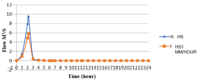
Natural phenomena that occur often cause disasters and losses for the community and cause some losses both from social, financial, education and so on. Therefore advances in the world of construction and technology in the scope of water here play a very important role in analyzing a disaster that occurs, one of which is flooding. Based on the method used in this research is descriptive quantitative where the analysis is carried out by modeling the cross-sectional capacity of the watershed using the help of HEC-RAS software with a case study of river capacity analysis for rainfall in the watershed in Nagari Kampuang Galapuang Ulakan with a river stem length of 19 km and an area of river 115 km² the analysis interview process was carried out directly to the local community affected by the incident and resulted in a conclusion explaining that the Batang Ulakan Watershed can reach its maximum discharge in just 2 hours 6 minutes 25 seconds. To achieve a peak discharge of 9.51 m³/s from its normal discharge. And during the 25 to 50 year planned rainfall return period, the cross-sectional capacity data found that the geological conditions which have elevations that are not much different between the river sections and residents' settlements have little difference, resulting in the Batang Ulakan Watershed section, Nagari, Galapuang Village, on average, overflowing as high as 0.447 m in each of the Batang Ulakan Region Watershed in the Galapuang Village
Downloads
References
Agustina A, et al. (2022). Analysis of River Flow Characteristics in the Cimadur River, Banten Province Using Hec-Ras. Vol. 03 No. 01 Pages 31-41.
Alfianto. (2017). Padang Pariaman Regency In Figures Padang Pariaman Regency In Figures. Padang Pariaman: Bps Padang Pariaman Regency.
Amri K, et al. (2018). Hydrological Analysis to Obtain the Peak Discharge of the Bengkulu River Using the Nakayasu Synthetic Unit Hydrograph. Vol. 6 No. 2 Pg 82-87.
Erni and Nugroho A. (2022). Mapping Rice Harvest Yields in Central Java Using the Thiessen Polygon Method. Vol. 3 No. 4 Pages 460-465.
Kristanto W A D. (2018). Technical Geological Characteristics of Prambanan and Surrounding Areas, Prambanan District, Selamat Regency, Special Region of Yogyakarta. Vol. 3 No. 2 Pages 21-29.
Mamuaya F L, et al. (2019). Analysis of the cross-sectional capacity of the Roong Tondano River against various flood return periods. Vol. 7 No. 2 Pg 179-188
Ningsih D H U. (2012). Thiessen Polygon Method for Predicting Rainfall Distribution for Certain Periods in Areas That Do Not Have Rainfall Data. Vol. 17 No. 2 Pages 154-163
.
Pangestu H and Haki H. (2013). Analysis of Total Sediment Transport on the Dawas River, Musi Banyuasin Regency. No. 1 Vol. 1 Pg 103-109.
Rahardjo P N. (2014). 7 Causes of Flooding in Densely Populationd Urban Areas. Vol 7 No. 2 Pages 205-213
Rosyidie, A. (2013). Floods: Facts and Impacts, and the Effects of Land Use Changes. Vol 24 No 3 Pages 241-249.
Downloads
Published
Issue
Section
License
Copyright (c) 2024 Lili Leilany, Nadra Arsyad

This work is licensed under a Creative Commons Attribution 4.0 International License.


