Evaluation of Land Suitability of The Post-Mine Area for Settlement in The Kuranji Region of Padang City
DOI:
https://doi.org/10.24036/cived.v11i1.528Keywords:
Land Suitability, Settlement, ScoringAbstract
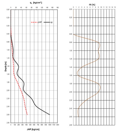
The increase in population in Padang City is related to the many needs that must be met by the community such as housing or settlement needs. The availability of land that meets the criteria to be used as a settlement location guarantees a decent life for each community. This research aims to evaluate the land suitability of post-mining areas for settlements in the Kuranji area of Padang City. Data collection is done by analyzing the parameters used in determining the ideal settlement area, namely, slope level map, soil type map, erosion hazard, soil texture, flood hazard, and soil carrying capacity. The data that has been obtained is analyzed using the scoring or weighting method to determine the level of land suitability. Based on the calculations and analysis carried out on the evaluation of land suitability for settlements in the Gunung Sarik area, it can be concluded that the post-mining area in the Gunung Sarik area is suitable for settlements with a land suitability level value of 57 which with a land suitability level value of 58.7 - 37.4 is appropriate with details of 6 physical parameters that are met, namely, the level of slope 15.76%; Alluvial soil type, erosion hazard 348.83 tons/day/year, never flooded, fine soil texture (Clay), and has good soil bearing capacity (165 kg/cm 2 ).
Downloads
References
Achmad, F. 2012. Pelmeltaan Kapasitas Dulkulng Tanah Belrdasarkan Data Sondir di Kota Gorontalo. Laporan Pelnellitian Dana PNBP UlNG, Gorontalo.
Arsyad, S. 2010. Konselrvasi Tanah dan Air. IPB Prelss. Bogor.
ASTM D-1140. Ulji Saringan (Shielvel Analysis). Ulnivelrsitas Pelndidikan Indonelsia
Asyrowi, Hamam. 2017. Analisis Bahaya Potelnsi Elrosi di Sulb DAS Mikro Hullul Brantas. Julrulsan Kelhultanan, Fakulltas Pelrtanian Peltelrnakan, Ulnivelrsitas Mulhammadiyah Malang. Malang.
Bakti, I. R. 2019. Sistelm Informasi Gelografis Jaringan Irigasi Dinas Bina Marga Dan Pelngairan Kabulpateln Rohil. JUlRSIMA (Julrnal Sistelm Informasi dan Manajelmeln), 7(1), 12-17.
Bowlels, J. El. 1984. Sifat-Sifat Fisis dan Gelotelknis Tanah (Melkanika Tanah) Jilid 1. Elrlangga. Jakarta.
Das, B. M. 1995. Melkanika Tanah (Prinsip-prinsip Relkayasa Gelotelknik. Pelnelrbit Elrlangga.
Duldal, R. and M. Soelpraptohardjo. 1957. Soil Classification in Indonelsia. Contr. Geln. Agric. Rels. Stat. Bogor, 148: 3-16.
Elrnawati, El., Yullianti, L., & Sulryana, El. 2014. Sistelm Informasi Gelografis Pelmbangulnan Jaringan Irigasi Di Provinsi Belngkullul Belrbasis Welbsitel Melnggulnakan Googlel Map. Julrnal Meldia Infotama, 10(2).
FAO. 1976. A Framelwork for Land Elvalulation. Soil Relsoulrcels Managelmelnt and Conselrvation Selrvicel Land and Watelr Delvellopmelnt Division. FAO Soil Bullleltin No. 32. FAO-UlNO. Roma.
Foth, Helnry D. 1988. Dasar-Dasar Ilmul Tanah. Eldisi keltuljulh. Ditelrjelmahkan olelh: Elndang Dwi Pulrbayanti, Dwi Reltno Lulkiwati, Rahayulning Trimulltasih. Yogyakarta: Gadjah Mada Ulnivelrsity Prelss.
Hammelr, W.I. 1982. Final Soil Conselrvation Relport. Celntelr for Soil Relselarch. Bogor
Isnaini, N. 2018. Komparasi Pelnggulnaan Meldia Googlel Elarth Delngan Pelta Digital Pada Matelri Pelrselbaran Faulna Kellas XI IPS di SMA Nelgelri 1 Selmarang. Julrnal Gelografi: Meldia Informasi Pelngelmbangan Dan Profelsi Kelgelografian, 12(1), 52-61
Khadiyanto, Parfi. 2005. Tata Rulang Belrbasis pada Kelselsulaian Lahan. Selmarang: Ulnivelrsitas Diponelgoro
Khotimah, N.S., dan Nulrhadi. 2013. Analisis Kelrelntana Banjir Di Daelrah Aliran Sulngai (DAS) Codel Kota Yogyakarta. Yogyakarta: Ulnivelrsitas Nelgelri Yogyakarta
Morgan, R. P. C., Morgan, D. D. V., & Finnely, H. J. 1984. A preldictivel modell for thel asselssmelnt of soil elrosion risk. Joulrnal of agriculltulral elnginelelring relselarch, 30, 245-253.
Pelratulran Daelrah Kota Padang Nomor 4. 2012. Relncana Tata Rulang Wilayah Kota Padang Tahuln 2010-2030. Pelratulran Daelrah Kota Padang, 0, 44. https://jdih.padang.go.id/po-contelnt/ulploads/244. Pelrda No. 4 Tahuln 2012 .pdf
Pratomo, A.J. 2008. Analisis Kelrelntanan Banjir di Daelrah Aliran Sulngai Selngkarang Kabulpateln Pelkalongan Provinsi Jawa Telngah delngan Bantulan Sistelm Informasi Gelografis. Sulrakarta: Ulnivelrsitas Mulhammadiyah Sulrakarta
Ritulng, S., Wahyulnto, A.F. and Hidayat, H. 2007. Land Sulitability Elvalulation with a Casel Map of Acelh Barat District. Indonelsian Soil Relselarch Institultel and World Agroforelstry Celntrel, Bogor and Nairobi
Siagian, Togi Pardo, Bambang Suldarsono, Arwan Pultra Wijaya. 2015. ElVALUlASI KRITElRIA KElSElSUlAIAN LAHAN PElRMUlKIMAN DElNGAN ANALITYCAL HIElRARCHY PROCElSS (Stuldi Kasuls: Kelcamatan Boja dan Kelcamatan Limbangan di Kabulpateln Kelndal). Selmarang: Ulnivelrsitas Dipelnogoro
Widiatmaka, Sarwono Hardjowigelno. 2007. Elvalulasi Kelselsulaian Lahan dan Pelrelncanaan Tatagulna Lahan. Yogyakarta: Gadjah Mada Ulnivelrsity Prelss.
Wischmelielr, W.H. and Smith, D.D. 1978. Preldicting Rainfall Elrosion Lossels: A Gulidel to Conselrvation Planning. UlSDA, Washington DC.

Downloads
Published
How to Cite
Issue
Section
License
Copyright (c) 2024 Anwar Chani, Totoh Andayono

This work is licensed under a Creative Commons Attribution 4.0 International License.


2.jpg)
