
Tsunami Vertical Evacuation Building Analysis (Shelter) Based on Number and Location: Case Study of Koto Tangah District- Padang City
DOI:
https://doi.org/10.24036/cived.v11i1.509Keywords:
Shelter, Location, Tsunami, Evacuate, InundationAbstract
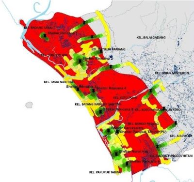
Koto Tangah Sub-district is a sub-district where part of its area is located on the coast, making it prone to tsunami disasters. Despite the fact that the large number of exposures in the tsunami red zone predicted to happen in this District, there are only three tsunami shelters in the red zone of Koto Tangah District. The purpose of this study was to determine the distribution of official shelters in Koto Tangah District, the distribution of planned shelters, and the coverage of shelter service areas. The research method used is a quantitative descriptive method. In this study, what is discussed is the number and location of shelters, as well as the location of the planned tsunami shelters. Also, this present study sought to finding out the coverage area that can be served by the shelter with the help of GIS applications. The results of the data analysis are as follows: (1) There are nine villages (kel.) that are in the tsunami red zone of the Koto Tangah District and are not served by official shelters, namely: Kel. Padang Sarai, Kel. Batipuh Panjang, Kel. Lubuk Buaya, Kel. Pasia Nan Tigo, Kel. Batang Kabung Ganting, Kel. Koto Pulai, Kel. Koto Panjang Ikua Koto, Ex. Dadok Stumping Black, and parts of Ex. Parupuk Tabing. (2) The analyzed planned shelters and horizontal points examined that all of the Koto Tangah red zone areas can be served by shelters, and the planned shelters can be reached in the span of 34.5 minutes with a distance of 1554.57 m, meaning that people who are in the tsunami red zone can evacuate safely before the tsunami hits the city. (3) local government needs to add another 6 planned shelters in Kel. Padang Sarai, Kel. Lubuk Buaya, Kel. Pasie Nan Tigo, Kel. Batang Kabung Ganting, and Kel. Parupuk Tabing, with each shelter's planned height of 8.5 meters.
Downloads
References
Sujarto, D. & Budiharjo, E. (1999). “Sustainable Cities.” Bandung: Alumni Publisher.
Grace, Akbar. (2022). "Analysis of Services to Fire Hazard Vulnerability Based on the Number and Location of Fire Offices (Case Study: Padang City)." CIVED Journal (Volume 9 No. 2 June 2022). p. 130-142.
Ashar, F., Amaratunga, D., & Haigh, R. (2014). The Analysis of Tsunami Vertical Shelter in Padang City. Procedia Economics and Finance 18 (2014). Hlm. 916-923.
Alfian, Syahputra. (2017). Location Priority Determination ModelShelter In the Emergency Response Phase in Padang City Using the AHP-Topsis Method. Diploma thesis, Andalas University.
Yunanda, Rezko., Hidayat, Benny., Istijino, Bambang., & Taufika, Ophiyandri. Readiness Analysis Of Public Buildings In Padang City For Tsunami Temporary Evacuation Shelter. International Journal of GEOMATE, June, 2022, Vol.22, Issue 94, pp.113-120.
Padang City Disaster Risk Assessment Document for 2023-2027. BPBD Padang City.
Downloads
Published
Issue
Section
License
Copyright (c) 2024 Faisal Ashar, Rika Ampuh Hadiguna, Muhammad Faisal

This work is licensed under a Creative Commons Attribution 4.0 International License.


